
Aug. 29, 1985, Salmon NF (ID) Butte Fire IMT Aerial Ignition Firing Operation Entrapped 118 WFs & FFs, 73 Required Fire Shelters. Erratic Fire Weather. Pre-Buying Cases of Military Body Bags? P3
- Aug 6, 2025
- 25 min read
Updated: Aug 7, 2025
Restating the post title beyond the limited Wix title allowance: Aug. 29, 1985, Salmon NF (ID) Butte Fire IMT Aerial Ignition Firing Operation Entrapped 118 WFs & FFs, 73 Required Fire Shelters. Erratic Wildland Fire Weather & Fire Behavior. Pre-Buying Cases of Military Body Bags? P3
Authors Fred J. Schoeffler, Jim Steele, and other contributing authors

Figure 1. So. Cal. CNF Laguna HS hiking Butte Fire dozer line Source: LHS
Views expressed to "the public at large” and "of public concern"
Obsidian Finance Group vs. Crystal Cox, US Courts.gov Opinions
DISCLAIMERS to follow: Please fully read the front page of the website (link below) before reading any of the posts. This includes that you must be at least 18 years of age or older to view this website and these posts.
This post is based on the author's professional judgement and opinions based on available evidence, with no intention to defame individuals.
The authors and the blog deny responsibility for misuse, reuse, recycled, cited, and/or uncited copies of content within this blog by others. The content, even though presented publicly, if being reused, must get written permission in doing so, due to copyrighted material. Thank you.
Abbreviations used: Wildland Firefighters (WFs) - Firefighters (FFs).
All emphasis is added unless otherwise noted.
The wisdom of the prudent is to understand his way,
But the folly of fools is deceit.
Proverbs 14:8 (NKJV)
Go from the presence of a foolish man, When you do not perceive in him the lips of knowledge. The wisdom of the prudent is to understand his way, But the folly of fools is deceit.
Proverbs 14:7-8 (NKJV)
"If you want to know who rules over you,
look at who you are not allowed to criticize."
George Orwell - Eric Arthur Blair, better known by his pen name,
was an English novelist, essayist, journalist, and critic. (1903-1950)
Carrying over from Parts 1, & 2, this Part 3. deals primarily with the wildland fire weather and fire behavior aspects for this fire. You may want to bone up on this wildland fire weather subject. On the word of this author - a maverick - this post is about a wildland fire many FFs and WFs considered a historical near-death wildland fire, skirting near Biblical proportions. The time has finally come to reveal it after 40 years. On or about August 25, 1985, the renowned U.S. Forest Service U.S.F.S. (USFS) Southwestern Area (SWA) Payson, Flagstaff, and Mormon Lake Hot Shots were assigned to the Butte Fire on the Salmon NF near Salmon, Idaho. Upon landing in Boise, Idaho, this author recalls having a strong, hinky, strange, and uncomfortable gut feeling about this fire from the get-go. More than likely, it was the Holy Spirit, the more it's pondered. We later received a concise, informative briefing at the Salmon N.F. Indianola Ranger Station. We were expressly told that the "trigger points were 20% RH (Relative Humidity) or 4:00 P.M., whichever came first." And so, for the following three days (Aug. 25-28, 1985), that is what we experienced and witnessed with fairly aggressive fire behavior each day. However, the fire weather changed dramatically on Aug. 29th when we got 20% RH at 1:30 PM, which then required a critical change in safety and tactics. The Payson HS and Flagstaff HS, the Lolo NF Engine Strike Team (E-ST), a Dozer, and a Water Tender would eventually utilize a clear-cut as our Safety Zone (SZ). The two HS Crew Bosses (before the eventual Supt. moniker) and the E-ST, for the most part, always ultimately considered the clear-cut as our true SZ! To the best of this author's memory, the Mormon Lake HS utilized a different area as a Safety Zone because they called us on the TAC channel and asked how we were doing as the fire behavior increased. This author then asked, "How is your weather?" He stated something to the effect of it being "crystal clear" so this author responded something to the effect of "Then you need to get the f**k out of there." He also stated that they "had to run for over a mile because a spot fire" increased in intensity and "took off." And that their "tool handles" eventually burned, as well as their "drip torches and fuel cans" left behind. See Schoeffler and Steele Declarations.
Critical Decision Making in Wildland Fire: Demystifying Intuition with the Recognition-Primed Decision Making Model (2024) Oliver Simic, Western Washington Univ. Environmental Studies. MA candidate
Harnessing the Power of Intuition (2024) Hoai Huong Tran. IEEE Insight.
Book Summary – The Power of Intuition: How To Use Your Gut Feelings To Make Better Decisions At Work. (2025) Readingraphics
The Power of Intuition: How to Use Your Gut Feelings to Make Better Managerial Decisions (2010) Fred C. Lunenburg; Sam Houston State Univ.
Intl. Journal of Mgmt., Business, and Administration, Vol. 13, 1,
From hire to retire: Leading with intuition. The Firefighter's Sixth Sense (2024) Arjuna George. Canadian Firefighter
Improving Wildland Firefighter Performance Under Stressful, Risky Conditions: Toward Better Decisions on the Fireline and More Resilient Organizations (1995) Dr. Ted Putnam et al. Missoula, Montana
We ignore the power of intuition at our peril (2022) Brookman, G.
Because this author often uses quotes, it's essential to address them here in this cited quote: “It’s important to bear in mind that quotations are, almost by definition, statements removed from their original context, i.e., brief statements taken from an often vastly larger work. Even in cases where the quotation is brief, to the point, and matter-of-fact, the larger work may frame it in a particular way that might get lost or muted when considered apart from it. In addition, people are often inconsistent. A person may say one thing in a particular work and then say something quite the opposite in another, or sometimes even the same work.” Propaganda, deception, and persuasion (2005) Laird Wilcox. This is an excellent source with 1,122 well-meaning quotes from various individuals.
The History of Brainwashing - This out-of-the-ordinary Australian Broadcasting (2023) podcast is by author, historian, and psychoanalyst Daniel Pick. Brainwashed: A New History of Thought Control
Imagery involves visualizing an event in a way that can influence our actions, so you know this author fully takes advantage of that advice.

Figure 1a. former PHS Schoeffler Snippet Source: BFSR PR
The author in Figure 1a. is without a mustache. It was after the Butte Fire that growing a mustache was somehow to protest what occurred there. In addition, this author lied about the 200 ft. flame heights because of the intended focus of the alleged investigation, when one of the investigators, talking with someone on the phone after the shelter deployments, stated: "there were a lot of f**k-ups on this fire, but we are going to make sure the reports says that fire shelters worked and saved lives."
The Butte Fire Staff Ride Preliminary Report (BFSR PR) stated: "Weather Forecast - At the August 29 morning briefing Bill remembers the meteorologist saying that the weather that day would be pretty much a carbon copy of the day before. And, of course, we didn't have any major runs the day before,” Bill says. “We had small runs down in the steep chimneys in Owl Creek—but no major runs.” ... That morning, Bill also recalls how the meteorologist said that the weather that day was going to be a little more unstable. “Well,” Bill acknowledges in retrospect, “neither he nor anybody else realized what that really meant for us that day.” ... Later that afternoon when the fire blew up, from Bill’s position in the helicopter, he could see eight other big smoke columns from ongoing fires on the adjacent National Forests. “All of them were standing up with strong columns.” ... Bill says that this change in atmospheric instability on the Butte Fire helped prompt the study that led to the establishment of the Haines Index, based on atmospheric instability.

Figure 1b. Incident Meteorologist (IMET) fire weather forecasting Snippet Source: NWS
Consider this Firefighter Nation (2018) quote from their article titled: You Swore an Oath - "As firefighters, we all take an oath of office as a solemn promise to defend the Constitution of the United States. While each jurisdiction’s oath may vary, they all contain the same substantive language that each individual shall uphold the Constitution and that he will faithfully and impartially discharge the duties of his office and obey the laws of his state and city. Many fire departments expand on the oath to include a willingness to place others above themselves and to follow the regulations of the department." Therefore, these authors have never relinquished their respective Oaths of Office; therefore, the truth will be revealed here on these Butte Fire posts.
Sooner or later ... one has to take sides – if one is to remain human.
Graham Greene (novelist, short story writer, travel writer, and critic)
In a time of universal deceit, telling the truth is a revolutionary act.
George Orwell
Consider now Snippets of the AZ Highways July 1987 Butte Fire article.
Figure 2. AZ Highways July 1987 Wildfire Snippet Source: PHS M. Conner

Figure 3. AZ Highways July 1987 Wildfire Snippet Source: PHS M. Conner
Figure 4. AZ Highways July 1987 Wildfire Snippet Source: PHS M. Conner

Figure 5. PHS Saw Boss in the clear-cut Snippet Source: PHS M. Conner
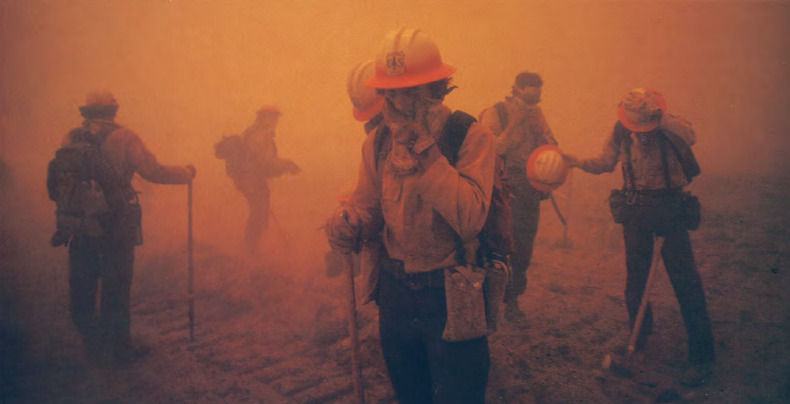
Figure 6. PHS in carbon monoxide clear-cut Snippet Source: M. Conner

Figure 7. PHS Crew Boss Schoeffler and acting Flagstaff HS Crew Boss Roy Hall fast asleep in clear-cut pre-burnover - August 29, 1985, Snippet Source: PHS, Joy A. Collura
Strike Team Leader (STL) Ebberts kicked this author while asleep in the clear-cut on Aug. 29, 1985, and told us to "wake up and get back to work." This author responded: "You need to get everyone into the clear-cut with us because the fire was coming out." He eventually deployed his shelter with the rest of them, his second deployment. Schoeffler Declaration
Considering the debatable human factors aspect of the job, you'll want to: Trust your Instincts - Be at home in Nature - Keep your Den Clean - Stand by what you Believe In - Stay on Track - Howl with your Friends - Be a Leader - Pack life with Good Memories. Advice from a WOLF (FB).
On Sheep, Wolves, and Sheepdogs - LTC (RET) Dave Grossman, author of "On Killing." (Tree House Letter 2025)
Sheep vs. Wolf vs. Sheepdog: Which Mentality Dominates Your Life? Knowledge for Men (2023)
The “Sheepdog” Analogy is Deeply Flawed (2022) The Havock Journal. Gregory D.
“However much you deny the truth, the truth goes on existing.”
George Orwell
Consider now the germane free Effectiviology (2025) Belief Bias article.
"The belief bias is a cognitive bias that causes people to over-rely on preexisting beliefs and knowledge when evaluating an argument, instead of properly considering the argument itself.
This bias leads people to accept arguments that align with their preexisting beliefs, even if those arguments are weak or logically unsound, and to reject arguments that contradict their preexisting beliefs, even if those arguments are strong and logically sound.
For example, the belief bias can cause someone to accept the argument “all flowers have petals, and roses have petals, therefore roses are flowers”, because they know that roses are flowers; however, this argument’s conclusion does not follow from its premises, and its premise that "all flowers have petals" is wrong.
Factors like the structure of an argument influence whether and how someone will display the belief bias, as well as how they will respond to debiasing attempts.
You can use various techniques to reduce the belief bias in yourself and others, like explaining what this bias is, slowing down the reasoning process and making it explicit, asking whether the belief bias could be influencing the reasoning in question, and identifying specific errors in reasoning."

Figure 8. Decisions and Outcomes matrix Snippet Source: Schoeffler
There were several of the Fireline Overhead and Crew Leaders who fell headlong into the Bad Decisions With Good Outcomes realm!
In the spirit of transparency, what follows is a fairly precise rendition (with author bold highlighting) of an Artificial Intelligence (AI) reply to a Google search for the following excerpt: "Breakdown of the Upper Level Ridge and the 1985 Butte Fire: The Butte Fire of 1985 on the Salmon National Forest in Idaho, part of the Long Tom Complex, provides a case study of how a combination of factors, including weather patterns, can contribute to extreme fire behavior. While the direct influence of a specific upper-level ridge is not explicitly detailed in the provided information, the broader atmospheric conditions were a critical contributing factor. Key Factors Contributing to Extreme Fire Behavior on August 29, 1985: Drought Conditions: Severe drought persisted throughout the summer of 1985, leading to exceptionally dry fuels, which were easily ignited and sustained intense fire. Fuel Conditions: the exceptionally low fuel moisture levels, coupled with abundant fuel sources like spruce-fir stands and lodgepole pine, allowed for rapid fire spread. Unstable Atmosphere: Post-fire investigation revealed unstable lower atmospheric conditions, which contributed to the fire's explosive growth. Reverse Wind Profile: A reverse wind profile, where wind direction changes with altitude, also played a role in the fire's rapid spread. Topography: Steep slopes and continuous fuels on the ridge tops allowed for rapid upslope runs and a lack of natural barriers to slow the fire. Fire Behavior: The fire exhibited extreme behavior, including large, high-intensity crown fire runs, rapid spread rates, and towering smoke columns. Role of the Upper Level Ridge: While not explicitly named, an upper-level ridge could potentially contribute to the extreme fire behavior observed in the Butte Fire incident. Upper-level ridges are Warm and Dry Conditions: They often bring warm, dry air, exacerbating existing drought conditions and lowering fuel moisture levels. Winds: Ridges can also influence wind patterns, potentially creating or enhancing conditions conducive to rapid fire spread, such as the reverse wind profile observed during the Butte Fire. In the case of the Butte Fire, the post-fire investigation specifically pointed to unstable lower atmospheric conditions and a reverse wind profile as key contributors to the fire's explosive growth. While the precise role of a specific upper-level ridge in creating these conditions is not detailed in the provided materials, it's plausible that a strong, persistent ridge over the region contributed to the overall warm, dry conditions and influenced the atmospheric stability that fueled the fire's rapid spread. In summary: the Butte Fire was a complex event with multiple contributing factors. While a specific upper-level ridge was not explicitly identified, the overall weather pattern, including severe drought and unstable lower atmospheric conditions, played a significant role in creating the conditions that led to the fire's extreme behavior and the entrapment of firefighters. The incident underscores the importance of understanding the intricate interplay between weather, fuels, and topography in predicting and mitigating wildfire risks." End of AI response
A wise man proportions his belief to the evidence.
David Hume
Consider now this mind-boggling, helpful Pennsylvania State University, Department of Meteorology electronic map wall, which is also known as the e-wall website. Followed by archive August 1985 NOAA NCEP-NCAR Reanalysis Statewide Average Temperature and Palmer Drought Index (PDI) images (1948-2018), and several NOAA 20th Century Reanalysis images are from the Josh Timlin Archive and Historical Weather website.

Figure 8. Statewide average temperature Snippet Source: UQAM Centre

Figure 9. June-August Palmer Drought Index Snippet Source: UQAM Centre

Figure 10. 500 mb Temp. (K) Snippet Source: 20th Century Reanalysis
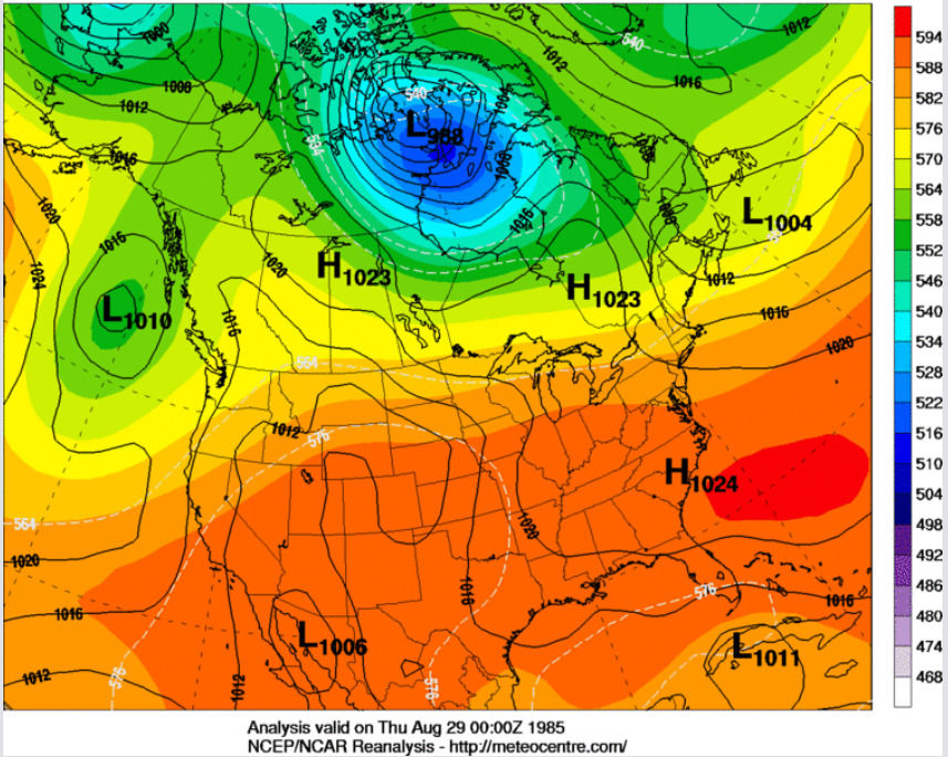
Figure 11. Aug. 29, 1985, 00Z archive wx renalysis Snippet Source: NCEP NCAR

Figure 12. Aug. 29, 1985, 12Z archive wx renalysis Snippet Source: NCEP NCAR

Figure 13. Aug. 29, 1985, 18Z archive wx renalysis Snippet Source: NCEP NCAR

Figure 14. Aug. 30, 1985 Snippet Source: ??

Figure 15. CPS Solar Heating - Fuel Moisture Snippet Source: Campbell
The following NOAA Renalysis Composite Mean wildland fire weather images formula for converting Kelvin (K) to Fahrenheit (F) is [(Temp. in K − 273.15) × 9/5 + 32 = F temp.].

Figure 16. Aug. 29, 1985, 700 mb composite mean temps (K) Snippet Source: NOAA, NCEP/NCAR Reanalysis

Figure 17. Aug. 29, 1985, 850 mb composite mean temps (K) Snippet
Source: NOAA, NCEP/NCAR Reanalysis

Figure 18. Aug. 29, 1985, 700 mb composite mean RH (K) Snippet
Source: NOAA, NCEP/NCAR Reanalysis
The truth has no defense against a fool determined to believe a lie.
– Mark Twain
Have I therefore become your enemy because I tell you the truth? Galatians 4:16 (NKJV) also attributed to Martin Luther, Sermons on the Gospel of St. John: Chapters 17-20, Luther’s Works, vol. 69, p. 216.
"People don't realize how hard it is to speak the truth,
to a world full of people that don't realize they're living a lie."
Edward Snowden
Consider now the Great Basin portion of the NWCG Weather: Fire Season Climatology, which includes parts of Idaho, Nevada, and Utah.
Critical Weather Events
Breakdown of the Upper Ridge
Subtropical Ridge
Edge of a Monsoon Burst (Hybrid)
Foehn or Downslope Wind (Chinooks down the east slopes of the Sierras and the west slopes of the Wasatch Mountains)
Climatology
Winter – periodic precipitation, mainly over mountains.
Spring – becoming windy, dry, and warmer.
Summer – hot and dry. Periodic wind events north and moisture surges south.
Fall – period of windy and dry conditions often followed by a period of fair and dry weather before cooler temperatures and increased precipitation potential.
Fire Activity
Generally, fine fuel types, fire season is dependent on cured fuels and windy/dry conditions.
These conditions occur almost exclusively in the summer.
Little to no activity outside of summer.
Fire Growth Potential Indicators
ERC and BI
National Fuel Moisture Database
LFI/GSI
AVHRR satellite NDVI DA and RG
NWS QPE (30-60 days)
NASA SPoRT RSM 0-10 cm/GVF
Drought Monitor
Consider now the informative Western Regional Climate Center information on the Climate of Idaho (2025), including the topography, temperature, precipitation, snowfall, and humidity. Several punctuation, spelling, and grammar liberties were taken by this author.
"Topographic Features - Idaho lies entirely west of the Continental Divide, which forms its boundary for some distance westward from Yellowstone National Park. With a maximum north-south extent of 7° of latitude, its east-west extent of 6° of longitude at latitude 42° N., but only 1° of longitude at 49° N. The northern part of the state averages lower in elevation than the much larger central and southern portions, where numerous mountain ranges form barriers to the free flow of air from all points of the compass. In the north, the main barrier is the rugged chain of Bitterroot Mountains forming much of the boundary between Idaho and Montana. The extreme range of elevation in the state is from 738 feet of the confluence of the Clearwater and Snake Rivers to 12,655 feet at Mt. Borah in Custer County. Comprising rugged mountain ranges, canyons, high grassy valleys, arid plains, and fertile lowlands, the state reflects in its topography and vegetation a wide range of climates. Located some 300 miles from the Pacific Ocean, Idaho is, nevertheless, influenced by maritime air borne eastward on the prevailing westerly winds. Particularly in winter, the maritime influence is noticeable in the greater average cloudiness, greater frequency of precipitation, and mean temperatures, which are above those at the same latitude and altitude in the midcontinent. This maritime influence is most marked in the northern part of the state, where the air arrives via the Columbia River Gorge with a greater burden of moisture than at lower latitudes. Eastern Idaho's climate has a more continental character than the west and north, a fact quite evident not only in the somewhat greater range between winter and summer temperatures, but also in the reversal of the wet winter-dry summer pattern."

Figure 19. Aug. 29, 1985, Long Tom Lookout & Tin Cup Hill Snippet Source: Google Earth
Standing alone for what’s right often inspires others to stand with you. Courage is contagious. The good man’s consistency gives others permission to be strong. Example empowers those that waiver.
Stoics
"Temperature
The pattern of average annual temperatures for the state indicates the effect of both latitude and altitude. The highest annual averages are found in the lower elevations of the Clearwater and Little Salmon River Basins, and in the stretch of the Snake River Valley from the vicinity of Bliss downstream to Lewiston, including the open valleys of the Boise, Payette, and Weiser Rivers. At Swan Falls, the annual mean is 55° F, the highest in the state. Obsidian, at an elevation of 6,780 feet in Custer County, has the lowest annual average, 35.4° F, of any reporting station, with places such as Sun Valley, Chilly Barton Flat, Grouse, Island Park Dam, and Big Creek not far behind. The range between the mean temperature of the coldest and warmest months of the year varies from less than 40°F at a number of northern stations to well over 50°F at stations in the higher elevations of the central and eastern parts of the state. In the basin of the Snake River and its tributaries, between Twin Falls and Idaho Falls, monthly mean temperatures of 32°F or lower persist from December through February, while downstream from Twin Falls, at the lower elevations, monthly mean temperatures are freezing or below only in December and January. Low-level stations like Riggins and Lewiston show no month in the year with a mean temperature 32° 32°F or lower. In general, it can be said that monthly means are 32°F or lower at stations above 5,000 feet from November through March; between 4,000 and 5,000 feet, November through February; 3,000 to 4,000 feet, December through February; and 2,000 to 3,000 feet, only one or two months. The diurnal range of temperature is, of course, most extreme in high valleys and in the semiarid plains of the Snake River Valley. The magnitude of diurnal range varies with the season, being lowest in winter when cloudiness is much more prevalent, and greatest in the warmer part of the year. At Boise, for example, the average diurnal range is only 14° F in January, but exceeds 30° F in July through September. Temperatures can range from -60° to 118° F. The coldest monthly mean minimum temperature has been -20° F, and the warmest monthly mean maximum has been 104° F. The highest long-term annual average has been 55°F at Swan Falls Power House, and the lowest long-term average has been 35°F at Obsidian. In summer, periods of extreme heat extending beyond a week are quite rare, and the same can be said of periods of extremely low temperatures in winter. In both cases, the normal progress of weather systems across the state usually results in a change at rather frequent intervals. In the realm of extremely low temperatures, two winters stand out in the records for the state: 1937-38 and 1948-49. The lowest monthly mean temperatures on record occurred throughout the state in January 1949, and many stations registered the absolute lowest temperature on record during that month.
Precipitation
To a large extent, the source of moisture for precipitation in Idaho is the Pacific Ocean. In summer, there are some exceptions to this when moisture-laden air is brought in from the south at high levels to produce thunderstorm activity, particularly in the eastern part of Idaho. The source of this moisture from the south is the Gulf of Mexico and the Caribbean region. The average precipitation map for Idaho is as complex as the physiography of the state. Partly because of the greater moisture supply in the west winds over the northern part of the state (less formidable barriers to the west) and partly because of the greater frequency of cyclonic activity in the north, the average valley precipitation is considerably greater than in southern sections. Peaks on the average annual precipitation map are found, however, in nearly all parts of the state at higher elevations. Sizeable areas in the Clearwater, Payette, and Boise River Basins receive an average of 40 to 50 inches per year, with a few points or small areas receiving in excess of 60 inches. Large areas, including the northeastern valleys, much of the Upper Snake River Plains, Central Plains, and the lower elevations of the Southwestern Valleys, receive less than 10 inches annually. Seasonal distribution of precipitation shows a very marked pattern of winter maximum and midsummer minimum in the northern and western portions of the state. In the eastern part of the state, however, many reporting stations show maximum monthly amounts in summer and minimum amounts in winter. In the Northeastern Valleys and Eastern Highlands, more than 50 percent of the annual rainfall occurs during the period from April through September. Over nearly all of the northern part of the state, however, less than 40 percent of the annual rainfall occurs in this same period, and in portions of the Boise, Payette, and Weiser River drainages, less than 30 percent of the annual amount comes in those six months.
Snowfall
Snowfall distribution is affected both by the availability of moisture and by elevation. Annual snowfall totals in Shoshone County have reached nearly 500 inches. The greatest long-term (1942-56) seasonal average was 182 inches at Mullan Pass, while the greatest snow depth (also 182 inches) was recorded at that station on February 20, 1954. The major mountain ranges of the state accumulate a deep snow cover during the winter months, and the release of water from the melting snowpack in late spring furnishes irrigation water for more than two million acres, mainly within the Snake River Basin above Weiser. Irrigation water supplies are nearly always plentiful, except on some of the smaller projects where storage facilities are inadequate. Electric power in increasing amounts is generated by the waters of the many rivers of the state.
Humidity
Humidity, as a climatic factor, seems to hold a great deal of interest for many people, yet it is one of the more elusive weather elements to deal with statistically. The diurnal range of relative humidity generally follows a pattern that is the reverse of the diurnal temperature curve. Precipitation or fog interferes with such a pattern, but the averages show maximum humidity at the time of minimum temperature and vice versa. In winter, average relative humidities are considerably higher than during the hot weather. Human comfort during the summer months is greatly affected by the moisture content of the air. In Idaho, where maximum temperatures above 90° are not uncommon in July and August, humidity at the time of maximum temperature is usually below 25 percent, and often down to 15 percent or lower. With any kind of air movement, the higher temperatures are quite within the range of adjustment of the human system. The low relative humidity of summer also permits widespread use of evaporation-type coolers. Field drying of hay is facilitated by the dry air, especially when air movement is sufficient. Some work has been done on the drying of corn and grain without the addition of heat, but in the season when this activity is carried on, the days are shorter and the periods of lower relative humidity are rather brief.
Storms
Windstorms are not uncommon in Idaho, but the state has no destructive storms such as hurricanes, and an extremely small incidence of tornadoes. Windstorms associated with cyclonic systems, and their cold fronts, do some damage to trees each year, often causing temporary disruption of power and communication facilities, but only minor damage to structures in most instances. Storms of this type may occur at any time from October into July, while during the summer months, strong winds almost invariably come with thunderstorms. Hail damage in Idaho is very small in comparison with damage in areas of the central part of the United States. Often, the hail that occurs does not grow to a size larger than one-half inch in diameter, and the areas affected are usually small. Quite often, hail comes during early spring storms, when it is mostly of the small, soft variety with a limited damaging effect. Later, when crops are more mature and more susceptible to serious damage, hail occurs in widely scattered spots in connection with summer thunderstorms. The incidence of summer thunderstorms is greatest in mountainous areas, where lightning often causes serious forest and range fires."
Western Regional Climate Center
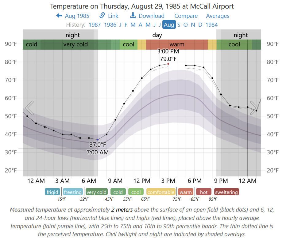
Figure 20. Aug. 29, 1985, McCall, ID temp Snippet Source: Weather Spark
According to the archive Old Farmer's Almanac website, the August 29, 1985, Salmon, ID minimum temperature was 57.9 degrees and a maximum temperature of 91.9 degrees, indicating potentially critical to blow-up conditions fire behavior as noted just below in the Bates' paper quote.
Please note that the high nighttime temperatures are all well with within the Critical to Blowup potential. Consider the USA RAWS Salmon, ID data in Figure 20a. below that clearly reflects a minimum temperature range at 0500 of 49.3°F degrees to an 0800 reading of 59.2°F squarely placing those readings into the critical to blowup potential realm.

Figure 20a. USA RAWS Salmon, ID 8-28-29-85 wx data Snippet Source: DRI
Please note that the high nighttime temperatures are all well within the Critical to Blowup potential thresholds in Fig. 20. and Fig. 20a. that the high nighttime temperatures from midnight to 0600 indicate the potential critical fire behavior to blow-up condition thresholds posited by classic works of former TNF PRD District Ranger Robert Bates noted in his most informative and insightful 1962 paper titled: "A Key to Blow-up Conditions in the Southwest?" paper (FMT 63, 3 Summer 2003). "A deadly one-two combination of an unusually warm night followed by a warm day may indicate blowup fire conditions. ... I have arbitrarily said that nighttime temperatures above 45° (7° C) are critical; and with those above 55° (13° C), blow-up conditions exist." In addition, "Of particular significance is the fact that most of them occurred following the warmest nights of the critical June fire period and often occurred at a peak after several consecutive days of rapidly rising temperatures." In comparison, the June 1990 Dude Fire and the June 2013 YH Fire experienced high nighttime temperatures in the blowup potential 60s and mid-70s, respectively, for several days before the fatalities.

Figure 21. Archive Aug. 29, 1985, WX map Snippet Source: NOAA NWS National Meteorological Center

Figure 22. Aug. 29, 1985, 12Z Boise, ID Skew-T Snippet Source: Plymouth

Figure 23. Aug. 29, 1985, 00Z Boise, ID Skew-T Snippet Source: Plymouth
“All great events hang by a single thread. The clever man takes advantage of everything, neglects nothing that may give him some added opportunity; the less clever man, by neglecting one thing,
sometimes misses everything.”
Napoleon
Consider now below the Google search AI response for a "Breakdown of Upper Level Ridge."
"Negatively Titled Shortwave - A negatively titled shortwave rotating around a larger upper level trough or a negatively titled shortwave absent of a larger upper level trough can cause an outbreak of dry thunderstorms as it moves across the WGB. A negatively titled trough is a trough that has an axis from southeast to northwest. A negatively tilted trough brings colder air aloft over warmer air at lower levels via cold air advection at mid and upper levels, helping to increase instability. Additionally, the tilt of the trough allows moisture to be entrained from the NAM to the north and west on the lee side of the Sierra. These two processes help create an environment conducive for dry thunderstorms. This environment consists of faster-moving storms and fringe NAM moisture, which helps limit the amount of rainfall reaching the ground and rainfall duration. Dry thunderstorm formation depends on mid-level moisture and instability. Wallmann et al. (2010), Nauslar et al. (2013), and Rorig et al. (2007) depict the best environments for dry thunderstorms and the forecasting of these environments for the western United States.
"On 4 August 1999, a negatively tilted upper-level ridge centered just east of the Rocky Mountains of Colorado, Wyoming, and Montana was downstream from a negatively tilted shortwave oriented along the California coast rotating around a larger upper-level trough off the Pacific Northwest Coast (Map 1). Precipitable water was marginal (15mm, Map 2), but HLTT exceeded 34 across most of the WGB (Map 3). This trough moved across the area on 4 August with the large negatively titled shortwave following a similar path on the following day, 5 August (Map 4). The deepest moisture stayed well to the east and south with marginal mid-level moisture remaining over northern and eastern Nevada, but with enough instability and moisture over most of Nevada as evident by the HLTT (Map 5; Map 6). Both these shortwaves produced thousands of lightning strikes that resulted in 98 total fires, with 34 becoming large fires (Map 7).
"Subtropical NAM/Upper Level Ridge - During late spring and early summer, an upper-level ridge of high pressure develops over the western United States. Frequently, it is centered near the Four Corners region, but depending on the size and strength of the ridge, it can be centered across the Great Basin and Intermountain West. When the ridge is positioned in a way that southerly flow pushes into the western portions of the Great Basin, thunderstorms develop. When the deepest moisture stays further to the south and east, but the WGB still resides on the fringe of the moisture usually located at mid and upper levels, dry thunderstorms can form. As moisture rotates around the ridge and enters the WGB, thunderstorms are triggered. If this moisture surge is short-lived or the deepest moisture doesn't push far enough north and west then the environment in parts of the WGB becomes conducive for dry thunderstorms with moist mid and upper levels over drier lower levels. The positioning of the ridge that induces this process happens frequently during the summer, but fuels and weather have to align for it to create a significant fire event.
"This pattern developed early in August 2000. An upper-level ridge of high pressure was centered over Utah, with moisture rotating around from the NAM moving across the WGB. Lightning occurred on 1 August over all but far northwest Nevada as moisture from the NAM moved northward (Map 2; Map 3), which helped destabilize the atmosphere (Map 4). This pattern persisted for the next four days, and moisture continued to rotate around the ridge and into the WGB, triggering mostly dry thunderstorms over drier fuels. The deepest moisture stayed to the south and east with only mid and upper level moisture making it into the WGB, generating mostly dry thunderstorms producing thousands of lightning strikes across the WGB (Map 5; Map 6; Map 7). By 4 August, lightning ignited 235 fires with 35 fires becoming large.
"Breakdown of Upper Level Ridge - An approaching upper level trough follows a period of high pressure ridging over the western United States, causing prolonged hot and dry conditions across southern Idaho, with the low pressure center to the north over northern Washington and shifting into northern Idaho and later over northern Montana. Dynamic instability in front of the approaching low, combined with mid-level moisture that is commonly advected into southern Idaho in the days preceding the trough's arrival, creates optimal conditions for dry thunderstorm activity and ignitions in the terrain of southern Idaho's Snake River Plain. As the trough moves over the region, the alignment of the upper-level west winds with the east-west oriented basin creates very strong winds at the surface, contributing to the rapid growth of any existing wildfires. These strong winds will continue in the post-frontal environment, as the trough moves to the northeast, and northwesterly winds continue to align with local topography, promoting fire growth. This pattern can happen quickly, over two days or it can last over several days when holdover fires become a problem.
?This pattern developed 12-15 July 2005, which yielded the Clover Fire in southern Idaho. An approaching upper-level trough began to flatten and breakdown an established upper-level ridge centered over the Great Basin 12-13 July 2005 (Map 1; Map 2; Map 3; Map 4). On 12-13 July 2005, HLTT and precipitable water plots support thunderstorm potential across the northern Great Basin (Map 5; Map 6). Thunderstorms developed over southern Idaho, producing lightning strikes that would eventually start multiple large fires, including the Clover Fire (Map 7). As the upper-level trough progressed, stronger winds and lower RH moved across the area, increasing fire spread on lightning-ignited wildfires (Map 8; Map 9)." End of AI answer.
Mistakes Were Made But Not By Me – Carol Tarvis, Elliot Aronson (2000)
Consider now some of the many legal aspects, authorities, and responsibilities of weather and weather forecasting. Essentially, they established weather information as a “public good”.
Weather Service Organic Act. 15 U.S.C. § 313.
Weather Research and Forecasting Innovation Act of 2017.
The Weather Act (2017)
Someone to Blame: Legal Liability for WX Forecasts (2003) Roberta Klein
18 U.S. Code § 2074 - False weather reports. Cornell Law Legal Institute
Federal Aviation Weather Roles & Responsibilities (2021)
Weather Government Grants (2025)
Fair Weather: Public-Private Weather Services (2003)
Legal implications associated with the use or control of fire (1991)
Wildfire season and fire weather: A media resource guide (2024)
Eyes on the Sky: A Day in the Life of an Incident Meteorologist (IMET) on the Front Lines of a Wildfire (2025)
Consider now the Declaration of former Butte Fire DIVS Jim Steele:
Consider now the answer to the post title question: "Aug. 29, 1985, Salmon NF (ID) Butte Fire IMT Aerial Ignition Firing Operation Entrapped 118 WFs & FFs, 73 Required Fire Shelters. Erratic Wildland Fire Weather & Fire Behavior. Pre-Buying Cases of Military Body Bags? Parts 1-3"
The time has come, 40 years later, to finally tell this story. Moreover, the answer should be axiomatic or self-evident based on the following: First off, listening to and heeding gut feelings, the Holy Spirit speaking to you. So then, if you see something or feel something, say something. Know and apply your basic knowledge regarding fuels and topography and basic fire behavior, the proven, tried-and-trued Rules of Engagement and Entrapment Avoidance principles, increasing more aggressive to explosive wildland fire behavior and increasingly more adverse wildland fire weather and based on the Aug. 29, 1985, Salmon NF (ID) Butte Fire IMT Aerial Ignition Firing Operation Entrapped 118 WFs & FFs, 73 Required Fire Shelters. Erratic Wildland Fire Weather & Fire Behavior. Pre-Buying Cases of Military Body Bags.
Fire is basically Fluid Dynamics. It flows like water, and the fire ALWAYS tells you what it’s going to do. ALWAYS! The Butte Fire showed us its intentions for days and virtually told us it was coming out on the afternoon of August 29. 1985.
And yes, both Steeel's and this author's Declarations proved that the IMT did, in fact, pre-purchase body bags from the military and very likely knew there would be fatalities based on OPS Bill William never calling any of us regarding our warnings to the Carson Hot Shots on the TAC frequency' and instead using the Command Channel statement to "Order up every troop flying helicopter we have in Idaho, we have at least 140 fatalities" strongly suggests that they knew and had allegedly had ill intentions.
Ultimately, it's up to you, the readers, to come to your own conclusions.
Part 1:
Part 2:
Part 3:
part 1 recording: https://youtube.com/live/vZOm6_lXwgc?feature=share
rest of posts saved as PDF by FJS 8-6-25 vs. recording due to Joy's health.
Declaration on Post One at bottom of page:
Recording of Declaration:


Joy A. Collura (Arizona Desert Walker) on X: "Executive Summary and Formal Declaration: A Survivor's Affirmation of Evidentiary Integrity and Call" / X
https://www.change.org/p/arizona-wildfires-accountability-prevention-flood-mitigation-in-grand-canyon
https://www.change.org/p/what-does-it-take-for-the-feds-to-investigate-arizona-law-enforcement-departments
I watched the old videos just now...I can comprehend now...sounds like compartmentalizing...and we address those topics when we do...I do that for my own fire. And I am just a housewife..this was their professional life
I have reviewed the declarations presented in these posts and was present for the "live", yet I remain unable to fully comprehend the underlying reasoning for their dissemination all these decades later except to tell their story. That is okay. I reckon. What tangible benefit or objective did they serve? The approach appears somewhat unconventional. It is conceivable that this originates from an internal whistleblower possibly seeking to highlight historical oversights; however, given that these events transpired four decades ago, the timing prompts questions regarding its current relevance. Ultimately, I find it challenging to endorse this content, as my considered advice is to prioritize more pressing contemporary matters that demand our collective attention. I want to be there for people, and…
https://youtube.com/live/vZOm6_lXwgc?feature=share
Honorable Governor Hobbs-
I am writing as a concerned citizen and advocate for wildland firefighters to urge your support in reevaluating the Wildland Firefighter Protection Act, introduced in 2023(also the 2025 -S. 160). This legislation, aimed at enhancing safety standards, compensation, and health protections for firefighters, warrants renewed examination in light of both historical and recent wildfire events that underscore persistent vulnerabilities in our nation's fire management systems.
As an advocate for understanding wildland fire and aviation trends across the United States and internationally, I have been deeply engaged in collecting and analyzing historical and current wildfire data. My goal is to ensure that accurate, authoritative information—such as that from the National Interagency Fire Center or Arizona’s Department of…