
Part One - Who Do We Continue to Distinguish And Read About as the Likely Participants in the Undeni
- Sep 9, 2023
- 31 min read
Updated: Apr 3, 2025
Part One - Who Do We Continue to Distinguish And Read About as the Likely Participants in the Undeniable Sesame to Shrine Corridor Fuel / Fire Break Possible Firing Operation?
2018-08-19 |
Views expressed to "the public at large” and "of public concern"
DISCLAIMER: Please fully read the front page of the website (link below) before reading any of the posts ( www.yarnellhillfirerevelations.com )
The authors and the blog are not responsible for misuse, reuse, recycled and cited and/or uncited copies of content within this blog by others. The content even though we are presenting it public if being reused must get written permission in doing so due to copyrighted material. Thank you.
"The more numerous the number of observations and the less they vary among themselves the more their results approach the truth." Pierre-Simon, Marquis De LaPlace (A Philosophical Essay on Probabilities page 73)
Consider now Marquis De LaPlace's quote above in the context of the Yarnell Hill Fire (YH Fire) on June 30, 2013. The number of convincing photos and videos of obvious smoke columns (plumes) in the Sesame Street and Shrine Corridor Fuel / Fire Break area are numerous and vary little among themselves, so the more these results seem to approach the truth of a Firing Operation.
This is for the naysayers and doubters that refuse to believe that the photos and videos presented here on this website show the possible progression of a firing operation and the steady succession of smoke columns (plumes), vouched for by numerous current and former Wildland Firefighters (WFs), and the resultant even and uniform fire edges.
There was always the possibility that these smoke columns (plumes) were generated by "ember storms" and flying embers. However, the spot fires and associated smoke columns (plumes) from these embers would generally show up as clusters and not in a uniformed linear fashion as repeatedly shown in the Sesame Street and Shrine Corridor Fuel / Fire Break area smoke columns (plumes). Keep in mind, spot fires are almost always with the wind, rarely against or into the wind.
Let's remember that one of the several contributing research specialists for a well-known author talked with a WF about his experience during a subsequent visit to the YH Fire. They had sometime later discussed the topic of whether a firing operation had occurred in this area because of a general consensus among many WFs on that tactic. That comment triggered one of the research specialists to recall that they had found burnt fusees in that area along/near the Sesame Street and Shrine Road Corridor during their subsequent site visit after the YH Fire. Fusees are a common tool used to ignite fires; they are a longer and longer-burning version of a common road flare.

Figure 1. Fusees defined in the SAIR. Source: SAIT-SAIR
SAIT-SAIR link ( https://sites.google.com/site/yarnellreport/ ) Link to terminology: ( https://docs.google.com/file/d/0B36DIycSgbzWSUtjNkl1Z2ROT0k/edit )
Note: It is very interesting that the SAIT-SAIR definition of fusees is: "widely used to ignite backfires." So then, we have to ask the question, why were burnt fusees found in that Sesame to Shrine Corridor Fuel / Fire Break area, as one WF stated to another WF (one being a Research Specialist) that re-visited the site after the fire?
Check out the short video clip below. This occurs on all wildland fires and the denser the fuels, the more embers that are generated. It's like a virtual snowstorm of embers, but it is instead a literal storm of hot, flying, rolling, sailing embers.
Figure 1a. YouTube video clip of "driving through an [Australian bushfire] ember attack". Source: YouTube; Flame Sniffer WD Published on Jan 14, 2010.
You will find that Part 2 contains a lot of reading material. It begins with the Wildland Fire Lessons Learned Center (WLFLLC) Ground Truths - Now What? This entire post will entail two (2) separate posts (same title with Part 2) and will consist of "Two More Chains" article titled: "by Travis Dotson with some questionable conclusions and comparisons., (i.e. news articles, the heavily redacted, yet informative Blue Ridge Hotshots (BRHS) Unit Logs; DIVS Rance Marquez's Unit Log; and in part two the following: " by Travis Dotson (Summer 2013, Vol. 3, Issue 2). He compares and contrasts the Yarnell Hill Fire (2013) and South Canyon Fire (1994) Investigations. There are also many more "Interview Notes" ( "notes compiled from recollections of, discussions between, the accident team members who interviewed people involved with the [YH Fire]") notably unredacted, yet informative, of many WFs and Supervisors, including the BRHS. I also include a May 29, 2018, WFLLC "Two More Chains" article titled: "Underslung Heroes" where I feel Dotson makes some dubious statements and conclusions.

Figure 2. Google Earth idealized image, looking Northwest (using "Snipping tool") indicating up-slope alignment of the Sesame Street To Shrine Fuel / Fire Break Corridor (upper center black horizontal arrows) to the parallel chimneys / chutes / washes (vertical curved black lines) leading up to the GMHS deployment zone. Boulder Springs Ranch (BSR) / Helms in the center right. Source: Paint and Yavapai County Records Request 7-9-14\Audio video recordings\Video Files; FA42 IMG_1584.MOV July 4, 2013, 2:34pm

Figure 2a. Google Earth idealized image (using "Snipping tool"), looking North along teal-colored sight-line form "Area 1" where photo was taken (black rectangle) aligning directly over the top of the BSR / Helms property (lowest yellow pin). The upper-right red horizontal solid line is the Sesame Street To Shrine Fuel / Fire Break Corridor. The two parallel solid red horizontal lines in the upper center are the washes / chutes / chimneys along an up-slope alignment leading up to the GMHS deployment zone. Boulder Springs Ranch (BSR) / Helms in the center right. The solid black curved line from the Area 1 box to the right "where Tex Gilligan parked" is the approximate hiking route we took back to Tex's vehicle. Source: Google Earth and Snipping Tool and Paint

Figure 3. Photo series (3,3a,3b,3c) of smoke columns (plumes) and fire behavior between 2:30 PM and 3:30 PM (1430 and 1530) that appeared "suddenly and out of nowhere" based on best-guess time estimates from memory and proximate notes because time stamps not accurate on camera; the plumes are in the direction of the BSR / Helms / Sesame Street to Shrine Fuel / Fire Break Corridor. Source: Joy A. Collura
Note: One could easily identify the time of this photo by researching the records for the Tanker 910 June 30, 2013, flights. Or they may be in the 3-ring binder(s) of the USDA/USFS Aerial Firefighting Utilization and Effectiveness (AFUE) Study they keep refusing to release these public records and deny they even exist.

Figure 3a. Photo from Lone Ocotillo Trail. Photo series of smoke columns (plumes) and fire behavior that appeared "suddenly and out of nowhere" between 2:30 PM and 3:30 PM (1430 and 1530) based on best-guess time estimates from memory and proximate notes because time stamps not accurate on camera in the direction of the BSR / Helms / Sesame Street to Shrine Fuel / Fire Break Corridor. Source: Joy A. Collura

Figure 3b. Photo series of smoke columns (plumes) and fire behavior between 2:30 PM and 3:30 PM (1430 and 1530) that appeared "suddenly and out of nowhere" based on best-guess time estimates from memory and proximate notes because time stamps not accurate on camera in the direction of the BSR / Helms / Sesame Street to Shrine Fuel / Fire Break Corridor. DC-10 Tanker 910 (link to my photo below) is visible in the left center. Source: Joy A. Collura
( https://photos.app.goo.gl/Q1z2nd2Tk2B9PGF77 ) Link to photo of DC-10 Tanker 910
( https://photos.app.goo.gl/YHy5wic4DxLvVY1Z6 ) Link to photo since it is widescreen panoramic
Figure 3c. Above link leads to photo as widescreen panoramic view only included in this series of smoke columns (plumes) and fire behavior between 2:30 PM and 3:30 PM (1430 and 1530) that appeared "suddenly and out of nowhere"based on best-guess time estimates from memory and proximate notes because time stamps not accurate on camera. Source: Joy A. Collura

Figure 4. IMT Fire Behavior Analyst (FBAN) Byron Kimball public records photo (unknown if Kimball was photographer) indicating fire behavior in the Sesame Street to Shrine Fuel / Fire Break Corridor, on the YH Fire on June 30, 2013, at 5:05 PM (1705) in the metadata insert. However, the "Name 1647 Fire at Structures Yarnell North End 06_30 Properties" suggests that the photo was actually taken at 4:47 PM (1647). Source: Yavapai County Records Request 7-9-14\SAIT Report and Documents\F-Photos And Videos\A14-20130630 Byron Kimball Photos

Figure 4a. Google Earth Street View (current) of where the photographer took the FBAN Kimball Figure 4. photo above was taken based on the camera GPS metadata, obviously minus the fire behavior. Compare the utility pole and transformer and wires seen in both Figure 4 and 4a. (angle is approximate) Source: Google Earth

Figure 4b. Google Earth Snipping Tool image indicating June 30, 2013, photographer's site (bottom right indicated with large white arrow); westerly (277.5 degrees) line-of-sight (yellow vertically diagonal line) toward the Sesame Street to Shrine Fuel / Fire Break Corridor (solid red northwesterly diagonal line); two parallel washes / chutes / chimneys (solid red, northwesterly parallel, diagonal lines); Boulder Springs (BSR) / Helms (labeled yellow pin); yellow pin at upper diagonal line terminus is GMHS Deployment Site. The June 30, 2013, photo in Figure 4, notes it was "Modified Sunday, June 30, 2013, 5:05:02 PM" (1705) in the metadata insert in Figure 4. The insert also interestingly notes: "1647 Fire at Structures Yarnell North End 06_30 Properties." However, the photo labelled "1647" highly suggests that the photo was actually taken at 4:47 PM (1647). Source: Google Earth, Paint, and Snipping Tool


Figure 4c. FBAN Byron Kimball Unit Log (two images) Snipping Tool images noting increased June 30, 2013, (1615 & 1645) fire behavior, fire movement observations, including the notation "(Photos)," one of which is shown above in Figure 4c in red outlined rectangle. Source: Yavapai County Records Request 7-9-14\SAIT Report and Documents

Figure 4d. Interview Notes excerpt from Chris Horyza (YH Fire position unknown) AZ BLM Planning and Environmental Coordinator at the time of the YH Fire. Snipping Tool image of Unit Log regarding June 30, 2013, 1630 (4:30 PM) what Horyza noted as "obvious ... extreme fire behavior" observations with the "fire ... continuing to push south" containing "fire-whirls ... that extended 200 feet in the air." (emphasis added) Source: Yavapai County Records Request 7-9-14 \ SAIT Report and Documents

Figure 4e. Snipping Tool/ Paint; Zoom and Crop used for the image of an actual YH Fire Smoke Whirl/Plume/Column near Model Creek on June 30, 2013. This complements both Esquibel and Horyza's fire behavior observations noted above and below. Source: Anonymous-by-Request
Note: Typically, when fire behavior is increasing in one sector of a fire, it is increasing in other areas as well.

Figure 4f. Idealized image indicating the Figure 4e. photographer's angle; above ground view. Yellow push pin in bottom center is where the photograph was taken June 30, 2013, that complements others' statements of seeing 200 ft. smoke whirls / plumes / columns. The single red line (upper center) is Sesame Street and Shrine Fuel/Fire Break Corridor. The two parallel red lines are the washes / chutes / chimneys aligned upslope to the Deployment Site (uppermost yellow "DZ" pin) Source: Google Earth, Snipping Tool

Figure 4g. Current Google Earth view indicating the photographer's (Figure 4e.) area at street view of the Model Creek School as shown on the sign. Source: Google Earth / Snipping Tool

Figure 4h. Showing the photographer's (Figure 4e.) angle above ground. Source: Google Earth / Snipping Tool
Horyza's fire behavior observations indicate that the outflow of North winds are occurring and the fire behavior is becoming more aggressive and it complements TFLD(T) Esquibel's fire behavior observations in his Unit Log.
What follows is Peoria FD FF Tyson Esquibel's (Task Force Leader 2 - Trainee) Unit Log regarding his actions and his astute fire behavior observations that he witnessed on the June 30, 2013, (1620-1645) YH Fire. The investigators slanted scanned captures are less than optimal.


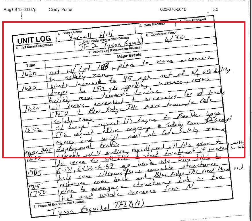
Figure 5. Peoria FD FF Tyson Esquibel's (Task Force Leader - Trainee) Unit Log regarding his actions on June 30, 2013, noted at 1445, to improve the dozer line toward the Shrine Road for a later burnout operation. Increased aggressive fire behavior is astutely noted at 1610 (Horizontal Roll Vortices - HRV) and from 1620 to 1630 Resources movements to Safety Zones. At 1632 Esquibel noted that "Structure Protection Specialist 1" (Gary Cordes) "request[ed] 1 [one] Engine to the BSR" all highlighted within the red rectangular text boxes. Source: Yavapai County Records Request 7-9-14\SAIT Report and Documents
It is particularly instructive that TFLD(T) Tyson Esquibel, a hybrid municipal FF, recognized Horizontal Roll Vortices (HRV) fire behavior for what it was, an indicator of very extreme burning conditions. The publication listed below is excellent; it details extreme fire behavior and covers HRVs quite well. There is also a Part 2 version. Chapter 7 begins to cover Vortices and Wildland Fire and HRV begins on p. 95.
Synthesis of Knowledge of Extreme Fire Behavior: Volume I for Fire Managers by authors Paul A. Werth, Brian E. Potter, Craig B. Clements, Mark A. Finney, Scott L. Goodrick, Martin E. Alexander, Miguel G. Cruz, Jason A. Forthofer, and Sara S. McAllister. USDA Forest Service, Pacific Northwest Research Station, General Technical Report, PNW-GTR-854, November 2011. ( https://www.fs.fed.us/pnw/pubs/pnw_gtr854.pdf ) Link here. You can order these by mailing or emailing to the address on the inside cover (they are free - your tax dollars at work).

Figure 5a. Idealized image of Horizontal Roll Vortices. Source: Finney, M.A. et al (2015) Role of buoyant flame dynamics in wildfire spread. PNAS. ( http://www.pnas.org/content/112/32/9833 ) Link here

Figure 5b. Bass River Fire July 22, 1977; New Jersey Pine Barrens. Eagleswood Volunteer Fire Department Four Fatalities (the FFs in this photograph all died as a result of the extreme HRV fire behavior in the photo) Source: NIFC Training Library Archive and WFLLC Incident Reviews - Bass Fire. ( https://www.wildfirelessons.net/orphans/viewincident?DocumentKey=ec1e4b8e-3604-4785-bb1d-fa420c7ef43f ) Link here
Consider now the ongoing involvement of the Peeples Valley FD and "Firefighter" Bob Brandon. The green highlighted text will be my comments regarding quotes within the various articles and/or posts. I will use the green text elsewhere in other areas as well to add clarity and to reduce confusion as to what was posted and what were comments to those posts.
"Bob Brandon Gets Caught in the Firestorm, Helps Rebuild" ( http://www.yarnellhillrecoverygroup.org/os_bob_brandon.html - link ) "The Yarnell Hill Recovery Group - Our Stories - Bob Brandon - Peeples Valley Firefighter Bob Brandon’s own words." (Figure 6 below)
"On June 30, [2013] 7:30 a.m., we all met for a briefing at Model Creek School, which was the Incident Command Post. The commander said we were in a sector, I don't remember if it was Zulu or not. But we were to go down Shrine as far as we could go to that abandoned house that's at the end. (all emphasis added) This is the Sesame Street to Shrine Fuel / Fire Break Corridor.
"Peeples Valley had two trucks. I was the tender driver. We were to go to that ranch house and then into the black area, the burned area west of that house, and we were to start clearing a roadway for a firebreak to connect with a bulldozer that would be coming from Glen Ilah so the fire could not come back into Yarnell." (all emphasis added) This is the Sesame Street to Shrine Fuel / Fire Break Corridor.
"But we were to go down Shrine as far as we could go to that abandoned house that's at the end. Peeples Valley had two trucks. I was the tender driver. We were to go to that ranch house and then into the black area, the burned area west of that house, and we were to start clearing a roadway for a firebreak to connect with a bulldozer that would be coming from Glen Ilah so the fire could not come back into Yarnell. ... I was just sitting by my tanker taking pictures of it because it was just kind of an awesome site [sic]. When he pushed though the woods and got to our location, all of a sudden, he turned around, did a 180 and took off. He never finished the roadway he was supposed to do for us. We were confused because now we had to finish it by ourselves. ... About that time, the Blue Ridge Hot Shots arrived on our scene and they started to march in. It was actually a two-pronged attack on this road we were supposed to be cutting. We were to the north and they were to the south of us along the bulldozed road. ..." (all emphasis added) This is the Sesame Street to Shrine Fuel / Fire Break Corridor.
"Then the sky started really looking funny. To that point we never had any smoke or fire to speak of that was threatening us. The fire was quite a ways away, about a mile. My lookout came down off the mountain and said that there was a problem because he just got the weather report and they talked about the changing winds, but he didn't understand what it meant." (all emphasis added) "The fire was quite a ways away, about a mile," then it's on top of them? What happened and where did this fire come from?
"We looked up behind Boulder Mountain [local vernacular for the general Sesame Street to Shrine area] and we noticed that the fire was standing straight up, right behind Boulder Mountain [local vernacular for the general Sesame Street to Shrine area] about 100 feet high. And we're thinking, That's not right. Because the fire was way north of us, clear up to Peeples Valley. ... " (all emphasis added) This matches what I posted in the Figure 3 photo series above of smoke columns (plumes) that appeared "suddenly and out of nowhere."
"The next day [July 2, 2013] they took us in and debriefed us. This was two days after the incident with the 19 [July 2, 2013]. They went through and looked at my pictures and took a flash card of them. And I don't know what they did with them, but it was pretty good because my pictures had timelines on them, so they could see what happened at what time. Then they took information off our cellphones because that's how we talked to, texted, each other. And those all had timelines on them, too. What time we were there. What time we were aware that the fire was about to overtake us. What time we got out. And some of the texts about whether we were safe." (all emphasis added). Where are these photos? And why have they been denied as existing in ongoing FOIA/PA Requests for myself and others?
This is the flowing paragraph consolidated version of what Peeples Valley Fire Department (PVFD) Bob Brandon recounted above: they "... were to go down Shrine as far as we could go to that abandoned house that's at the end. ... to start clearing a roadway for a firebreak to connect with a bulldozer that would be coming from Glen Ilah so the fire could not come back into Yarnell. ... to go down Shrine as far as we could go to that abandoned house that's at the end. ... to start clearing a roadway for a firebreak to connect with a bulldozer that would be coming from Glen Ilah so the fire could not come back into Yarnell. ... I was just sitting by my tanker taking pictures of it because it was just kind of an awesome site [sic]. ... the Blue Ridge Hot Shots arrived ... It was actually a two-pronged attack on this road we were supposed to be cutting. We were to the north and they were to the south of us along the bulldozed road. ... Then the sky started really looking funny. To that point we never had any smoke or fire to speak of that was threatening us. The fire was quite a ways away, about a mile. ... We looked up behind Boulder Mountain [local vernacular for the general Sesame Street to Shrine area] and we noticed that the fire was standing straight up, right behind Boulder Mountain ... That's not right. Because the fire was way north of us, clear up to Peeples Valley. ... The next day [July 2, 2013] they took us in and debriefed us. ... looked at my pictures and took a flash card of them. And I don't know what they did with them, but it was pretty good because my pictures had timelines on them, ... they took information off our cellphones ... And those all had timelines on them, ... And some of the texts. (emphasis added)
All of the above bolded excerpts put together in paragraph form immediately above are definitely referring to the Sesame Street to Shrine Fuel / Fire Break Corridor and the Firing Operation, including the fact that he gave the SAIT "Investigators" his and others' photos and cell phone data and copied to "flash cards" and these are nowhere to be found and even denied to exist in recent FOIA Requests as detailed in the following paragraph.
The following is based on a FOIA Request filed with the USDA Forest Service. Peeples Valley Fire Department (PVFD) Bob Brandon, engaged in wildland firefighting on the June 30, 2013, Yarnell Hill Fire (YH Fire) in Sesame Street and Shrine area. According to other public records, the YH Fire Serious Accident Investigation Team (SAIT) investigators Jim Karels and Randy Okon interviewed PVFD Bob Brandon on or about July 8, 2013. According to these public records, PVFD Brandon and other PVFD firefighters took over thirty (30) photographs on the June 30, 2013, YH Fire while engaged in The Shrine area. These photos were then given to USFS Incident Commander (IC) Clay Templin and/or his Type 1 IMT (Incident Management Team) and then exchanged with USFS Co-Team YH Fire SAIT Leader Mike Dudley in the form of a disk or “jump drive” or some other format on or about July 2013. According to these public records, USFS IMT IC Clay Templin stated it was PVFD Bob Brandon that gave IC Templin a “jump drive” and the IMT copied Brandon’s photos onto one of the “Smart Source laptops” which produced a CD for the YH Fire SAIT once they arrived. Dudley, Templin, and/or other USDA/USFS Employees have these public records in their possession.
However, recent FOIA Requests for the above information have come back negative, (i.e. "no records responsive to your request"). They fall into the category below of men and women who think they are above the law and of themselves as being unaccountable.
“There is no evil under the sun but what is to be dreaded from men, who may do what they please with impunity: They seldom or never stop at certain degrees of mischief when they have power to go farther; but hurry on from wickedness to wickedness, as far and as fast as human malice can prompt human power.”
“It is nothing strange, that men, who think themselves unaccountable, should act unaccountably.”
— Thomas Gordon, Cato’s Letters No. 33 (1721)
Bob Brandon Gets Caught in the Firestorm, Helps Rebuild.Sesame Street and Shrine Fuel / Fire Break Corridor and Firing Operation red outlined boxes " Relevant below.
( www.yarnellhillrecoverygroup.org/os_bob_brandon.html ) This link is still active, and references are within the article. Consider now an undated Yarnell Hill Recovery Group.org article written within the first year after the Yarnell Hill Fire, and it was posted on their website titled: "Yarnell Hill Fire Recovery Group"


Figure 6. PDF document converted to a JPEG image of the article titled: "Bob Brandon Gets Caught in the Firestorm, Helps Rebuild." My emphasized quotes above are from this post. The highlighted red rectangles are basically the same information quoted and emphasized above. Although the link is still active, it has been removed from the Yarnell Hill Recovery Group.org archives, so there is no way to confirm the date other than it was written within the first year or so after the YH Fire tragedy. Source: Yarnell Hill Recovery Group.org
Based on on Bob Brandon's dubious statements above regrading the distance he drove, what follows is breakdown (solid yellow line) of what 2-1/2 miles out from the Shrine Road actually "looks like." We know from the articles that PVFD "Firefighter" Bob Brandon was in the Sesame Street and Shrine Road Corridor area, So then, using the Google Earth Ruler Tool, I broke down each segment in Figures 6a to 6i of the alleged journey and come up with 1.28 miles and if he was coming to the Shrine Area from the Shrine Road, that puts him out by the Old Grader site or past it on the Weaver Mountains.
On the afternoon of July 20, 2018; 3:26 PM, I called Bob Brandon to clarify the status of my long overdue, June 2016 Public Records Request on the YH Fire because he is now PVFD Fire Chief Bob Brandon. He seems to think he is exempt from the AZ Public Records Act when he told me over the phone that he didn't have to give me any records because "you are not part of our Fire Department." I told him that it didn't matter and then he hung up on me. I reported his actions to the AZ Ombudsman and the AZ Attorney General. (The audio recording of this conversation will be coming in another post.)
In addition, neither the AZ Ombudsman nor the AZ Attorney General have replied to this legal Records Request complaint. PVFD stated to the Ombudsman that they gave the Requester "Joy A. Collura" everything, This is NOT factual. I did NOT get my requested records. Yet the PVFD tells me that the BLM has them, then the BLM tells me that PVFD has them because they are the record custodian, then PVFD tells me that AZ State Forestry has them, and AZ State Forestry states the PVFD are the Record Custodians. Smoke and mirrors. What kind of shell game are they playing here?
So then, I am just calling bullshit on a bullshit.

Figure 6a. Google Earth and Snipping Tool idealized image indicating that Bob Brandon is full of feculence with his statement that he drove approximately 2-1/2 miles back to the Shrine. In the above image, Bob Brandon said he drove to the Shrine and it was 2.5 miles??? from ???? These "???" designate when I question where was he coming from out in the dirt road areas that equals 2.5 miles. Yellow line on this image shows 2.5 miles out which is on the Weavers. Source: Google Earth

Figure 6b. Google Earth and Snipping Tool idealized image indicating that Bob Brandon is full of feculence with his statement that he drove approximately 2-1/2 miles back to the Shrine. Yellow line here is the segment measurement out from the Shrine to the start of the Sesame to Shrine Fuel / Fire Break Corridor designated by the red line. Source: Google Earth

Figure 6c. Google Earth and Snipping Tool idealized image indicating that Bob Brandon is full of feculence with his statement that he drove approximately 2-1/2 miles back to the Shrine. Yellow line here is the segment measurement out from the Shrine to the start of the Sesame to Shrine Fuel / Fire Break Corridor designated by the red line. Source: Google Earth

Figure 6d. Google Earth and Snipping Tool idealized image indicating that Bob Brandon is full of feculence with his statement that he drove approximately 2-1/2 miles back to the Shrine.Yellow line here is the segment measurement out from the Shrine to the start of the Sesame to Shrine Fuel / Fire Break Corridor designated by the red line. Parallel double red lines designate washes / chutes / chimneys leading upslope to the Deployment Zone. Source: Google Earth

Figure 6e. Google Earth and Snipping Tool idealized image indicating that Bob Brandon is full of feculence with his statement that he drove approximately 2-1/2 miles back to the Shrine. Yellow line here is the segment measurement out from the Shrine to the start of the Sesame to Shrine Fuel / Fire Break Corridor designated by the red line. Source: Google Earth

Figure 6f. Google Earth and Snipping Tool idealized image indicating that Bob Brandon is full of feculence with his statement that he drove approximately 2-1/2 miles back to the Shrine. Yellow line here is the segment measurement out from the Shrine to the start of the Sesame to Shrine Fuel / Fire Break Corridor designated by the red line. Parallel double red lines designate washes / chutes / chimneys leading upslope to the Deployment Zone. Source: Google Earth

Figure 6g. Google Earth and Snipping Tool idealized image indicating that Bob Brandon is full of feculence with his statement that he drove approximately 2-1/2 miles back to the Shrine.Yellow line here is the segment measurement out from the Shrine to the start of the Sesame to Shrine Fuel / Fire Break Corridor designated by the red line. Parallel double red lines designate washes / chutes / chimneys leading upslope to the Deployment Zone. Source: Google Earth

Figure 6h. Google Earth and Snipping Tool idealized image indicating that Bob Brandon is full of feculence with his statement that he drove approximately 2-1/2 miles back to the Shrine. Yellow line here is the segment measurement out from the Shrine to the start of the Sesame to Shrine Fuel / Fire Break Corridor designated by the red line. Parallel double red lines designate washes / chutes / chimneys leading upslope to the Deployment Zone. Source: Google Earth
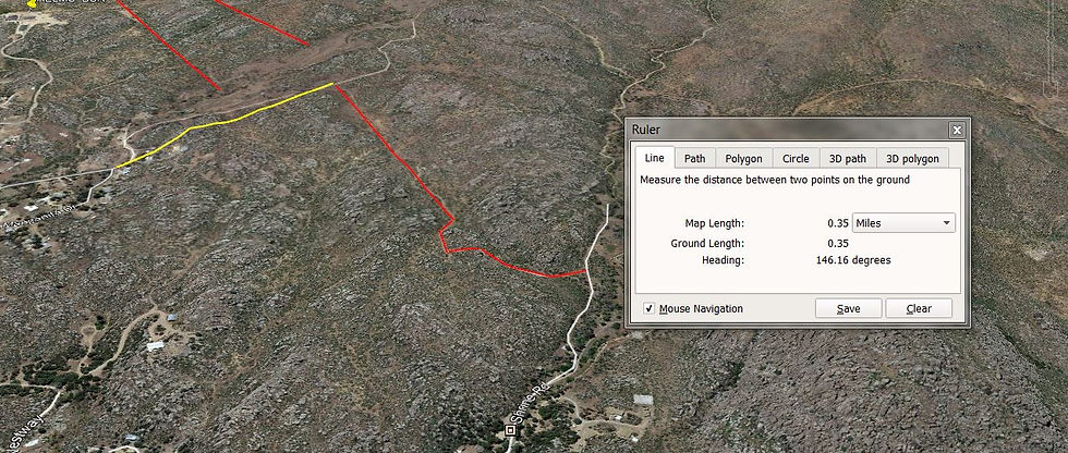
Figure 6i. Google Earth and Snipping Tool idealized image indicating that Bob Brandon is full of feculence with his statement that he drove approximately 2-1/2 miles back to the Shrine. Yellow line here is the segment measurement out from the Shrine to the start of the Sesame to Shrine Fuel / Fire Break Corridor designated by the red line. Parallel double red lines designate washes / chutes / chimneys leading upslope to the Deployment Zone. Source: Google Earth
What follows next are Snipping Tool photo images (some with metadata text boxes) of Air Attack Rory Collins from his June 30, 2013, 3:39:14 PM (1559:14) photo indicating fire behavior in the southern area of the Double Bar A Ranch Road to the left. The center right fire behavior and smoke columns (plumes) are the YH Fire.

Figure 7. Snipping Tool image of Air Attack Rory Collins June 30, 2013, 3:39:14 PM (1559:14) photo indicating fire behavior in the southern area of the Double Bar A Ranch Road in the lower left corner (rectangular open area). Figures 7 to 7c. are all the same image with varying explanatory text and metadata insets, including date and time in Figure 7b. and latitude and longitude in Figure 7c respectively. The fire behavior across the top center right is separate and distinct from any fire behavior in the Double Bar A Ranch Road area and is the YH Fire.. Source: Yavapai County Records Request 7-9-14\SAIT Report and Documents\F-Photos And Videos \ A02-20130629-30 Rory Collins Photos

Figure 7a. Snipping Tool image of Air Attack Rory Collins June 30, 2013, 3:39:14 PM (1559:14) video indicating fire behavior in the southern area of the of the W Double Bar A Ranch Road (rectangular open area). Figures 7 to 7c. are all the same image with varying explanatory text and metadata insets, including date and time in Figure 7b. and latitude and longitude in Figure 7c respectively. The fire behavior across the top center right is separate and distinct from any fire behavior in the Double Bar A Ranch Road area and is the YH Fire. Source: Yavapai County Records Request 7-9-14\SAIT Report and Documents\F-Photos And Videos \ A02-20130629-30 Rory Collins Photos

Figure 7b. Snipping Tool image of Air Attack Rory Collins June 30, 201,3 3:39:14 PM (1559:14) video indicating fire behavior in the southern area of the of the Double Bar A Ranch Road (rectangular open area). Figures 7 to 7c. are all the same image with varying explanatory text and metadata insets, including date and time in Figure 7b. and latitude and longitude in Figure 7c respectively. The fire behavior across the top center right is separate and distinct from any fire behavior in the Double Bar A Ranch Road area and is the YH Fire. Source: Yavapai County Records Request 7-9-14\SAIT Report and Documents\F-Photos And Videos \ A02-20130629-30 Rory Collins Photos

Figure 7c. Snipping Tool image of Air Attack Rory Collins June 30, 2013, 3:39:14 PM (1559:14) video indicating fire behavior in the southern area of the Double Bar A Ranch Road (rectangular open area). Figures 7 to 7c. are all the same image with varying explanatory text and metadata insets, including date and time in Figure7b. and latitude and longitude in Figure 7c respectively. The fire behavior across the top center right is separate and distinct from any fire behavior in the Double Bar A Ranch Road area and is the YH Fire. Source: Yavapai County Records Request 7-9-14\SAIT Report and Documents\F-Photos And Videos\A02-20130629-30 Rory Collins Photos
In the article about the "narrow escape" of the Peeples Valley FD firefighters and others while engaged in the YH Fire in the Shrine area on the "bulldozer" line, they mention that even with a lookout, they were surprised by the fire behavior that suddenly increased and almost caught them off guard. One of them even makes these unbelievable statements: "We didn't think we were in immediate danger, or they wouldn't put us in there" and "In the midst of the chaos he texted them and they said they were okay." (emphasis added)
Are you kidding me? They didn't think they were in immediate danger, or 'they' wouldn't put them in there? Wildland firefighting is an inherently hazardous job. Then he admits to actually texting them while they were in the midst of "chaos" and running for their lives, "two minutes from becoming a statistic." (emphasis added) Really? How about following accepted, normal procedure and using your radio to do that in the midst of chaos? Then there was also a fiasco with their "group supervisor" wanting them to move their vehicles (their Escape Route(s)?) while several FFs were cutting line in the brush. This illogical supervisory direction action could have been deadly.
Several other municipal FDs are mentioned in this Shrine Road article (i.e. Yarnell, PVFD, Wickenburg, and Sun City [West] FDs) along with the BRHS and the GMHS. Their fire behavior observations are very informative. Brandon stated that "the heat was just tremendous, it was like waves." (emphasis added) Brandon's fire behavior observation supports what TFLD(T) Tyson Esquibel noted with his documented Horizontal Roll Vortices in the Figure 5 series above.
In the article below in the third paragraph, "it was the same line that the Blue Ridge and the Granite Mountain hotshot crews were helping to build." (emphasis added) Why was this never discussed in the SAIT-SAIR / ADOSH reports? What part of the area are these men claiming the GMHS helped build? I thought we were all to believe they were on the Weavers in the black according the SAIT-SAIR. You read about the BRHS leaving the area, but after reading paragraph-after-paragraph, you no longer read about the GMHS. Where did they go if they were helping BRHS build the same fire line? Something does not add up. The other part that did not add up is the part where they said "At their shrine safety zone, they heard on their radios that the fire had breached one of the evacuation trigger points but they didn't know which one. They were suppose to have an hour from one of the trigger points to evacuate; they got about four minutes."
I am thinking of all the firefighters and homeowners who told me their accounts and the real time stamps of their photos and videos and comparing them to what I am reading here - that evacuation breach is the Metate Forest Trail / Lakwood / Manzanita / Sesame / Shrine / Deer Track areas. Note: It is Lakwood and NOT Lakewood even though proximate to each other.


Figure 8. PDF converted to a JPEG image article titled: "A Narrow escape: Peeples Valley firefighters recount that frightening day." The article includes details about the PVFD FFs Bob Brandon, Ron Smith, Jake Moder, and Matt Kehner, Yarnell, Wickenburg, and Sun City FDs involved in the June 30, 2013, Sesame Street and Shrine Fuel / Fire Break Corridor and the Firing Operation during the 3:00 to 4:00 PM (1500-1600) time frame. Source: AZ Daily Courier June 30, 2014, Joanna Dodder.
Based on the photo of the parked PVFD water tender in Figure 8, here is a Google Earth Snipping Tool/Paint image of the location above the Shrine at 16988 W Shrine Drive on Chung's 160 acres - that is accurate:

Figure 8a. Google Earth snipping tool image of the Figure 8 photo location, above the Shrine at 16988 W Shrine Drive on Chung's 160 acres. The solid red line in the lower left is the Sesame Street to Shrine Fuel / Fire Break Corridor. The white object in the upper-left orange rectangle above is the same white structure visible inside the fence line and behind the water tender in the photo. Source: Google Earth, Paint, and Snipping Tool
(Re)consider now DIVS Z Rance Marquez's Unit Log, posted elsewhere, is posted below since he and STL(T) Cougan Carothers (proper spelling compared to Rance's notes below) were (in)active participants, or at least witnesses, in what occurred in the June 30, 2013, Sesame Street and Shrine Fuel / Fire Break Corridor and the Firing Operation.

Figure 9. PDF converted to a JPEG image (cropped to reduce length) of DIV Z Rance Marquez Unit Log (September 26, 2013, 3:48 PM) with reference to STL (T) Cougan Carothers assigning water tenders around structures. Source: Yavapai County Records Request 7-9-14 Unit Activity Logs Rance Marquez Unit Log
Consider now the multiple, moderate to heavily redacted BRHS "Unit Logs" and statements below in Figure 10. from ADOSH Compliance Officer Brett Steurer to Wildland Fire Associates Investigators Barry Hicks and Dave Larsen. Almost all of these are really individual prepared statements from the BRHS Overhead and Crewmembers. They are well worth reading. It is fairly easy to infer names and/or positions and/or tasks being performed from the context. They include the BRHS Supt. Ass't Foreman, Squad Bosses, and Crewmembers.
It is interesting and disturbing, to note the many large blocks of redaction, obviously done by someone with the professional skills to do this. Most of those large redactions are critical and it is fairly clear to me that the BRHS have a lot to say and are more than willing to come forward and tell their story. Why is it that the US Forest Service have never allowed these BRHS to be interviewed by anybody, not even me?
It is important that will readily realize that most of the redactions have "(b5)" while a few have "(b6)" and/or "(b)(7)(F)." These are references to the Freedom of Information and Privacy Act (FOIA/PA) EXEMPTIONS in 5 USC 552 and 552a linked here courtesy of the "FOIAdvocates," a "project of FOIA attorneys David Bahr & Daniel Stotter designed to assist the public in gaining access to records from federal, state and local governments ..." ( http://www.foiadvocates.com/exemptions.html ) Definitely spend some time learning on this link (thank you law professor Elizabeth Nowicki for educating me on this area on FOIAs - you are a gem).
“The basic purpose of FOIA is to ensure an informed citizenry, vital to the functioning of a democratic society, needed to check against corruption and to hold the governors accountable to the governed.”
United States Supreme Court in NLRB v. Robbins Tire Co. - 437 U.S. 214, 242 (1978). (emphasis added)
There are nine (9) allowable "general" exemptions and then there is the Exemption (b) (7) that allows an additional six (6) "specific" subexemptions under the FOIA and I list the ones listed in the BRHS Figure 10 below. The FOIAdvocates website goes into much more detail on their website, including relevant case law supporting it, so it is well worth spending some time educating yourself if you want to learn more about the FOIA/PA Request process. The most common Exemptions utilized in the YH Fire records are discussed next. (emphasis added)
Exemption (b) (5) - Documents which are "inter-agency or intra-agency memorandum or letters" which would be privileged in civil litigation. 5 U.S.C. § 552(b)(5). (emphasis added)
Exemption (b) (6) - Documents which are "personnel and medical and similar files the disclosure of which would constitute a clearly unwarranted invasion of personal privacy." 5 U.S.C. § 552(b)(6). (emphasis added)
Exemption (b) (7) (F) - Documents which are "records or information compiled for law enforcement purposes," but only if one or more of six specified types of harm would result. 5 U.S.C. § 552(b)(7). Exemption (7)(F) protects law enforcement information which could reasonably be expected to endanger the life or physical safety of any individual. (emphasis added)
"Exemption 5 is an exemption very frequently invoked against public interest requesters because the nature of such party's intended uses are usually to get information regarding the agency's processes and conclusions. The exemption was intended to incorporate common-law privileges against discovery. Of all such privileges, the one most frequently encountered by public interest requesters is based on the concept of "executive" privilege which protects recommendations and advice which are part of the "deliberative process" involved in governmental decision-making. The rationale being to protect the integrity of agency decision-making by encouraging both full and frank discussions of policy proposals and to prevent premature disclosure of policies under review. The exemption also incorporates other of privileges which would apply in litigation involving the government."(emphasis added)
So then, you must ask yourselves, what do the BRHS Unit Logs and statements have to do with "medical" and "law enforcement" purposes? They have nothing whatsoever to do with medical or law enforcement purposes. The USDA USFS confidently knows they can get away with these feckless "disclosure of which would constitute a clearly unwarranted invasion of personal privacy" arguments. (emphasis added)
You will readily notice that the BRHS are more than willing to share their experiences and observations about June 30, 2013, however, they are constrained by supervisory direction prohibiting it and many others. Additionally, larger redacted areas generally indicate they are attempting to hide something.

Figure 9a. There have been people who do want to share their photos and accounts of the Sesame to Shrine Corridor and the YH Fire otherwise how is it they write like above in Social Media message but someone does not want them to talk. Who is that someone? How many more are out there like this? I wish more folks had this person's courage even if anonymously sharing. Source: Anonymously shared for "Lessons Learned" by a FF who was in the Sesame to Shrine area; Social Media
"However, in each case the justification for the deletion shall be explained fully in writing, and the extent of such deletion shall be indicated on the portion of the record which is made available or published, unless including that indication would harm an interest protected by the exemption in subsection (b) under which the deletion is made. If technically feasible, the extent of the deletion shall be indicated at the place in the record where the deletion was made." (emphasis in original) ( Amendments to the statute made by the 'Electronic Freedom of Information Act Amendments of 1996.' All newly enacted provisions are in boldface type. " ) Link provided. (emphasis added) Did they accomplish this and perform this legal requirement? They did NOT comply with the "justification for the deletion shall be explained fully in writing ..."
Now that you have completed your basic FOIA/PA Request 101 lesson, I did my best to list the BRHS Unit Logs and Statements in the numbered order they appeared in the Public Records Request. I focused on dialogue within the BRHS records that dealt specifically with even general statements about the Sesame Street to Shrine Fuel/Fire Break Corridor, the dozer line, a firing operation, and such. Therefore, it is not necessary to have them or read them in any specific order since they are separate statements, almost all on a single page. These are in the form of handwritten, typed, and even a General Message Form format.


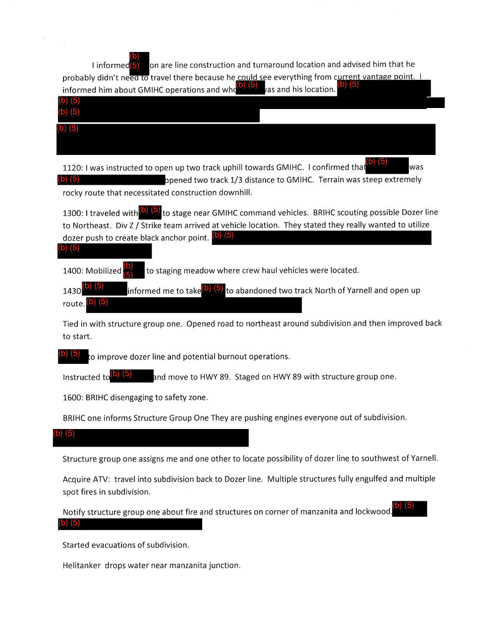
Figure 10. PDF in JPEG format image of Blue Ridge Hot Shot (BRHS) multiple, moderate to heavily redacted BRHS "Unit Logs" and statements.(BRHS weather readings record cropped to reduce length) Source: Blue Ridge Unit Logs dated November 7, 2013, referred to as the "Steurer emails" and "BlueRidgeIHC.pdf" from Brett Steurer, ADOSH Compliance Officer to Wildland Fire Associates Investigators Barry Hicks and Dave Larsen (RiP)
So now that you have considered the multiple, moderate to heavily redacted BRHS "Unit Logs" and statements above in Figure 10. What conclusions did you come to and were you fairly accurately able to infer the who, what, and where conclusions referenced within their Unit Logs and statements? And once again why is the US Forest Service not allowing the BRHS to be interviewed?
Did you find it interesting and disturbing regarding the many large blocks of redaction, obviously done by someone with the professional skills to do this? Did you also conclude that most of those large redactions are critical, and was it fairly clear to you as well that the BRHS have a lot to say and are more than willing to come forward and tell their story?
Proceed to continuation of the same title in a separate post: "Part 2 of Who Do We Continue to Distinguish And Read About as the Likely Participants in the Undeniable Sesame to Shrine Corridor Fuel / Fire Break Firing Operation?"
Part 2 contains the furtively posted and newly revealed to many of you, mostly unredacted YH Fire overhead and BRHS statements and interview "notes compiled from recollections of, and discussions between, the [SAIT] members who interviewed people involved with the [YH Fire.]" Spend the time to read through these, especially the BRHS notes. (emphasis added)
Part 2 also contains my additional post to my statement in the "notes compiled from recollections of, discussions between, the accident team members who interviewed people involved with the [YH Fire]" at PDF JPEG image page 31 (ASF 002313-INV to ASF 002314-INV), including links to some of the photographs and statements that I submitted to the YH Fire SAIT. These 24 links I provide in Part 2 are most informative and revealing and contain both photographs and narratives that the SAIT did NOT want included in their SAIR.
And below is a summary of what the BRHS has to offer in Part 2. The BRHS "recollections and discussion" accounts are a must read - filled with details on tactics, strategy, fire weather, fire behavior, human factors, DIVS Z, STPS Gary Cordes (Cortis), constructing and improving the "dozer line" along the Sesame Street and Shrine Road Fuel/Fire Break Corridor, "overwhelmed" Air Attack, a helitanker splitting the head into two heads, fixed wing and helicopter aircraft dropping at will with no direction, no good anchor points, discussions with GMHS Steed and DIVS A Marsh while in "the good black" in their Safety Zone and leaving and "making their way through [their] Escape Route, ... picking their way through the black to the [road] in the bottom out towards the ranch, ... non-stop, total chaos, scatter brained overhead, with the Rookie "seasonals say[ing] this is just like [the] Swiss Cheese effect," with the BRHS Foreman noting that "we need a piece of cheese. This is just one big hole." (emphasis added).
continue to part two: Part 2 - Who Do We Continue to Distinguish And Read About as the Likel (yarnellhillfirerevelations.com)
#wildlandfire #Yarnellfire #GraniteMountainHotShot #Undeniable Sesame to Shrine Corridor Fuel / Fire Break Possible Firing Operation # Pierre-Simon, Marquis De LaPlace #USDA/USFS Aerial Firefighting Utilization and Effectiveness (AFUE) Study (hashtags)
Post Number Twelve
© (All Rights Reserved) ( www.yarnellhillrevelations.com ) Disclaimer Copyright 2018
If you right click and click "print" and save as PDF- 67 pages.
Update October 20th 11:33pm- Fred J. Schoeffler has my full permission to use any and all content from "Part One - Who Do We Continue to Distinguish And Read About as the Likely Participants in the Undeniable Sesame to Shrine Corridor Fuel / Fire Break Possible Firing Operation?" on his new "Project 10 and 18 United" / "Project 10 and 18 International" blog he is creating.- Joy A. Collura


Comments